Saturday, 31 October 2009
Friday, 30 October 2009
Coogee, memorial
'Reclaiming Spirit' or the Bali Memorial is located in Dunningham Reserve at Dolphin Point, in the eastern suburb of Coogee. The four-metre high bronze sculpture created by Sasha Reid in 2003, dedicated to the Australian victims of the Bali bombings in 2002. Twenty were residents of the eastern suburbs, including six members of the Coogee Dolphins rugby league team. The four metre high sculpture represents three linked figures signifying family, friends and community. Bowed in sorrow and remembrance, they comfort, support and protect each other. Joined together they form a strong and supported whole structure. It's a really powerful image against the sky, looking out across the Pacific Ocean.
Thursday, 29 October 2009
Coogee, sundial
Wednesday, 28 October 2009
Coogee, Dolphin Point
A view of the Pacific Ocean from Dolphin Point at Coogee, just north of Coogee Beach. On a perfect sunny day last week, I managed to capture a reflection of the railing along the edge of the cliff, in a puddle which was the only evidence of rain on the previous night.
Tuesday, 27 October 2009
Coogee, drinking fountain
This heritage listed sandstone drinking fountain is no longer utilised but remains as an interesting monument in Goldstein Reserve, the park behind Coogee Beach. The name of the eastern suburb of Coogee comes from an Aboriginal word meaning 'stinking seaweed', a reference to the smell of decaying kelp on the beach.
Labels:
beaches,
fountains,
monuments,
parks,
Suburbs - Coogee
Monday, 26 October 2009
Cronulla, Greenhills
Sunday, 25 October 2009
Kurnell, cliffs and ship
A container ship heads out of Botany Bay at sunset, viewed from the sandstone cliffs of the southern headland, in the southern suburb of Kurnell.
Saturday, 24 October 2009
Macquarie Place Park
This heritage listed underground toilet is located at the northern end of Macquarie Place Park, in the city. Built in 1908, it has now been decommissioned and filled with sand, which preserves it and allows reuse in the future. The garden incorporates the above ground features such as the dome, walls, light, fence and decorative iron work used as a frame for climbing plants.
Friday, 23 October 2009
Angel Place, laneway art


Angel Place features an installation known as "Forgotten Songs", which is part of the Laneways: By George! Hidden Networks project. It features a canopy of empty birdcages hanging in the sky, accompanied by the sounds of Sydney's lost birds which may have lived in this area, before the city including this laneway, replaced their native habitats.
Click here to view all participants of Skywatch FridayThursday, 22 October 2009
Bridge Lane, laneway art
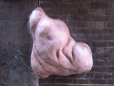
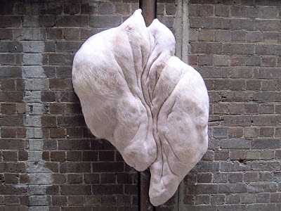
Bridge Lane features what might be the most bizarre art installation of the Laneways: By George! Hidden Networks project, currently on show. "I Dwell in the City and the City Dwells in Me" comments on how we create cities and how they in turn affect us. The pink blobs of prosthetic on the walls emulate human skin, complete with hair. Human sounds like breathing, gurgling and a heartbeat make this a truly unusual experience.
Wednesday, 21 October 2009
Underwood Street, laneway art
Underwood Street hosts the "Seven Metre Bar", an art installation which is part of the Laneways: By George! Hidden Networks project, which at night doubles as a bar called Grasshopper. Based on the theory that Climate Change will melt the polar ice caps and raise sea levels, Underwood Street at seven metres above sea level would drown. The artist combines the landscape of weather and an architecture of catastrophe with intense weather projections flickering and crashing in the laneway at night.
Tuesday, 20 October 2009
Penfold Place and Hosking Place laneway art
The art installation on the corner of Penfold and Hosking Place is called "Infinity Forest" and is part of the Laneways: By George! Hidden Networks project. From the outside it just looks like a few trees in a wooden box (left) but when you step inside (right), the mirrored walls provide infinite reflections, which creates an illusion of being in a forest.
Monday, 19 October 2009
Little Hunter Street laneway art
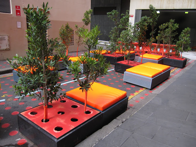
Little Hunter Street hosts a temporary art installation called "The Meeting Place", as part of the Laneways: By George! Hidden Networks project. This colourful, narrowed laneway encourages participation and interaction by pedestrians walking through this urban space.
The laneway connects Hunter Street to a shopping arcade, located below a skyscraper called Australia Square.
The laneway connects Hunter Street to a shopping arcade, located below a skyscraper called Australia Square.
Sunday, 18 October 2009
Tank Stream Way laneway art
This temporary art installation in Tank Stream Way is called "PS:Potential Spaces" and is part of the Laneways: By George! Hidden Networks project. The aim of the project is to enliven the city's urban spaces and also challenge us to think about our future. The laneways used are all nearby George Street, one of the main streets in the city. This installation explores possible future habitations in the city's laneways.
Linked to: Scenic Sunday
Saturday, 17 October 2009
Kogarah, graffiti art
Kogarah Library is currently showing a spray paint art exhibition called "Kogarah Spray On!". Most of it just looks like graffiti on plywood but I was impressed with this panting (left) of a Tangara train and a Railway Parade, Kogarah road sign, with the city skyline in the background.
Friday, 16 October 2009
Kogarah, railway line, sunset
This sunset on Monday produced some amazing colours in the sky above the railway line, in the southern suburb of Kogarah.
Click here to view all participants of Skywatch Friday
Click here to view all participants of Skywatch Friday
Thursday, 15 October 2009
Kogarah, mural
This mural on the wall of the Kaimaki Café along Post Office Lane in the southern suburb of Kogarah, It features local landmarks and symbols like the water reed which is a symbol of Kogarah, whose name was derived from an Aboriginal word for 'place of reeds'. The Dragon is a symbol of the local area of St George and landmarks include the Kogarah Community Centre building and Norfolk Island Pines along Botany Bay. There are also a whale and dolphins off the coast, pelicans and boys playing soccer and football in the St George colours of red and white.
Wednesday, 14 October 2009
Monterey, Scarborough Park
Scarborough Park, in the southern suburb of Monterey features a number of ponds connected by creeks.
Tuesday, 13 October 2009
Kogarah, fire station
The Kogarah Fire Station is a heritage listed building on the corner of Gray Street and Kensington Street, in the southern suburb of Kogarah. This building was built in 1907 in the Federation Arts and Crafts style. It was designed by government architect Walter L Vernon, who also designed the old Kogarah Post Office, which is now the Kogarah Post Office.
Monday, 12 October 2009
Kogarah, School of Arts
 The heritage listed Kogarah School of Arts is located on the corner of Bowns Road and Queens Avenue, in the southern suburb of Kogarah. The Victorian Italianate style building was opened in 1887 and restored in 1990. The two storey school was used for various art classes and technical education. The hall at the rear was used for theatrical performances, concerts, tea meetings, balls. Part of the building was used by the local council for the council chambers until 1912 and a portion housed the local library.
Sunday, 11 October 2009
Botany Bay, rainbow
We've had a had a lot of grey skies and spring showers over the last week. On Friday afternoon, I noticed this amazing rainbow in the sky and followed it to Botany Bay. By the time I was out of my car, the storm clouds started gathering again and the rainbow had lost some of its brilliance but I managed a couple of snaps before it disappeared.
Saturday, 10 October 2009
Conservatorium Road, King Edward VII
Conservatorium Road leads to the Sydney Conservatorium of Music, the Royal Botanic Gardens and Government House. This statue of King Edward VII on horseback is located on a traffic island, in the middle of Conservatorium Road.
Friday, 9 October 2009
Sydney Conservatorium of Music
A brilliant blue sky above the Sydney Conservatorium of Music, adjacent to the Royal Botanic Gardens. The Greenway Building, designed by convict architect Francis Greenway, was constructed in 1821 as the stables for the proposed Government House of New South Wales. The gothic building with turrets was described as a "palace for horses" and portrays the romantic vision of Governor Lachlan Macquarie and the British architectural trends of the time. It was converted to a music conservatorium in 1916 and today is part of the University of Sydney.
Thursday, 8 October 2009
Centennial Park, Federation Pavilion
The Federation Pavilion along the Grand Drive in Centennial Park commemorates the inauguration of the Federation of Australia at this site on 1 January 1901, when it became the focus of the nation. The original Federation Pavilion was an octagonal, domed structure made of plaster of Paris, richly decorated with bas-relief castings of native flora, which had degraded by 1903 and was removed. A replacement timber pavilion built here was later moved to a park in the inner west suburb of Cabarita. This Federation Pavilion is a rotunda designed by Alexander Tzannes, erected in 1988, the Bicentennial year of European Settlement. It was constructed around the 'Commonwealth Stone' as a permanent monument to Federation and features a glass domed ceiling with a colourful design. An inscription around the pavilion is from a poem by Bernard O'Dowd that reads: "Mammon or Millennial Eden". The building was renovated and plaques were added to celebrate the Centenary of the Federation of Australia on 1 January 2001.
Wednesday, 7 October 2009
Centennial Park, Busby's Pond
Busby's Pond is a large pond in the middle of Centennial Park which is home to many waterfowl. The pond is named after John Busby, Chief Surveyor, who in 1824 was responsible for finding an alternative water supply for Sydney's Tank Stream. He suggested a tunnel running from the freshwater swamps, that were located in this area, to Hyde Park in the city. The tunnel became known as Busby's Bore.
Tuesday, 6 October 2009
Monday, 5 October 2009
Centennial Park, Column Garden, Sunset
Sunday, 4 October 2009
Centennial Park, Column Garden
The Column Garden at Centennial Park, a large area of parkland in the eastern suburbs of Sydney. This area was once a huge catchment of creeks, swamps, springs, sand dunes and ponds fed by ground water. Centennial Park was dedicated as a public open space for the enjoyment of the people of New South Wales by Sir Henry Parkes in 1888 and named to celebrate the centenary of European settlement of Australia.
Linked to: Scenic Sunday.
Linked to: Scenic Sunday.
Saturday, 3 October 2009
Arncliffe railway station, dust storm
It's been a week since we had the biggest dust storm in 70 years but I had one more photo to share from that day of Arncliffe railway station on the T4 Eastern Suburbs & Illawarra Line, in the southern suburb of Arncliffe.
Linked to: Skywatch Friday.
Friday, 2 October 2009
Tom Uglys Bridge
Tom Uglys Bridge carries the Princes Highway over the Georges River. People were amused by the name of this bridge a few weeks ago, when I mentioned that it was in the distance of one of my sunset shots, so I took a few shots up close last week on a partly cloudy day. I explained the origins of the curious name "Tom Uglys" in my post yesterday. This view includes the northbound lanes on the 1937 truss bridge, the pedestrian walkway and one of the pylons. I was standing at the southernmost point of Blakehurst, looking south towards Sylvania.
Thursday, 1 October 2009
Tom Uglys Bridge (Theme Day: Contrast)
Subscribe to:
Comments (Atom)


