
Wednesday, 30 November 2011
Dawes Point, The Wharf Theatre
Tuesday, 29 November 2011
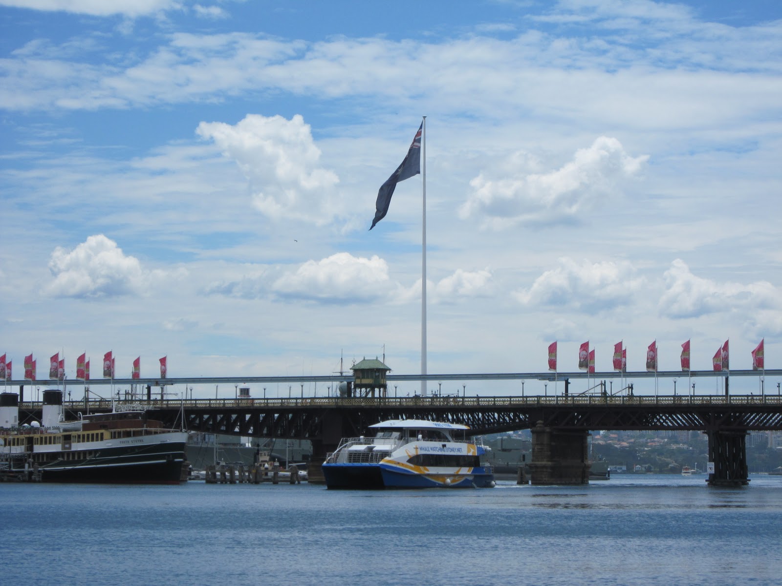
Millers Point, Walsh Bay

Walsh Bay is on Sydney Harbour, stretching between Dawes Point and Millers Point. This view of the wharves and Sydney skyline is from a ferry on the harbour. Pier 8 and Pier 9 of the Walsh Bay wharves, were originally part of Sydney's port facilities. The old warehouses on the wharves here have been redeveloped into commercial and residential spaces.
Monday, 28 November 2011
The Rocks, Australian Hotel

The Australian Hotel is located on the corner of Cumberland Street and Gloucester Street in The Rocks. This heritage listed pub that was built in 1913 in the Edwardian architectural style. It retains most of its original features and features a unique split level bar. The original Australian Hotel was built in 1824 in George Street but was demolished during the plague to prevent outbreaks. The licence was transferred to this building, making it the oldest continuously licensed pub in the City of Sydney.
Sunday, 27 November 2011
Dawes Point

A view of Dawes Point from a ferry travelling on Sydney Harbour. In front of the southern pylon of the Sydney Harbour Bridge are Ives Steps Wharf and Pier One on Walsh Bay. In the distance is the Sydney Opera House.
Saturday, 26 November 2011
Dawes Point, Walsh Bay

Walsh Bay is on Sydney Harbour, stretching between Dawes Point and Millers Point. Pier 2 and Pier 3 of the Walsh Bay wharves, were originally part of Sydney's port facilities. The old warehouses on the wharves here have been converted into theatres, galleries, offices, hotels, apartments, restaurants, cafes and shops. This view is from a ferry on Sydney Harbour.
Linked to: Weekend Reflections
Friday, 25 November 2011
Gold Fields House

Gold Fields House is a commercial office building at 1 Alfred Street, between Pitt Street and George Street, at Circular Quay. This 25 storey building was one of the city's earliest high rise office buildings, constructed in 1966. With spectacular views of Sydney Harbour, approval has been granted for it to be soon redeveloped into apartments. This view is from the walkway beside the Cahill Expressway.
Thursday, 24 November 2011
Dawes Point, Harbour View Hotel
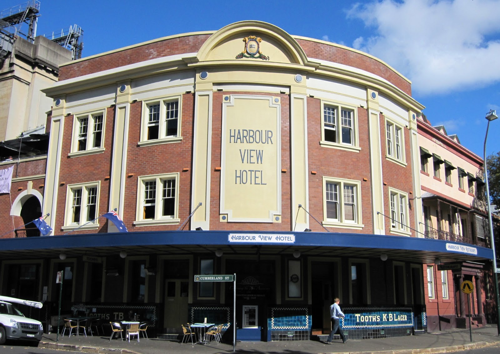
The Harbour View Hotel is located on the corner of Cumberland Street and Lower Fort Street at Dawes Point. The original Harbour View was demolished to make way for the Sydney Harbour Bridge. The pylon of the bridge now stands where the Harbour View Hotel previously stood. This hotel was constructed in 1924 and became a convenient watering hole for workers constructing the Harbour Bridge. The building was heritage listed and restored in 2001 with attention to its art deco style.
Wednesday, 23 November 2011
Dawes Point, Ives Steps Wharf

Ives Steps Wharf is located beside Pier One at Dawes Point, looking out on Sydney Harbour. The infamous Billy Blue operated a regular passenger boat service from Dawes Point across the harbour to Blues Point from 1830. The boat dock was approximately where the Ives Steps Wharf is now, but at that time it was called Waterman's Steps. They were renamed after Alderman Isaac Ellis Ives around 1896.
Tuesday, 22 November 2011
Hyde Park, garden

The remnants of a heritage listed underground public toilet is located at Hyde Park, along Park Street close to the corner of Elizabeth Street. Built in 1909, it has now been dicommissioned and filled with sand, which preserves it and allows for reuse in the future. The features above ground such as the the lamp post on a sandstone plinth and wrought iron stairway fences have been incorporated into the garden beds.
Monday, 21 November 2011
Hyde Park, Sandringham Gardens, gates

These decorative gates are part of Sandringham Gardens in Hyde Park North. Sandringham Gardens were developed to commemorate the intended visit of King George VI in 1952, which was cancelled due to his sudden death. In 1953, it was decided to dedicate the gardens as a joint memorial to the late King George V and the late King George VI. The memorial gates were unlocked on 5 February 1954 by the late King George VI's daughter, Queen Elizabeth II.
Sunday, 20 November 2011
Pyrmont Bridge, Darling Harbour
Pyrmont Bridge is a swing bridge that crosses Cockle Bay at Darling Harbour and connects the inner city suburb of Pyrmont with the Sydney central business district. The bridge was opened in 1902 but closed to traffic in the 1980s when freeways south of Cockle Bay were built. It reopened as a pedestrian bridge with the redevelopment of Darling Harbour in 1988. It also carries an elevated monorail with a track that remains stationary so that the monorails can continue to cross even when the bridge swings open for large boats.
Linked to: Sunday Bridges, Scenic Sunday.
Saturday, 19 November 2011
Circular Quay, Deerubbun

The Deerubbun is seen here departing on a tour from Circular Quay, with the Sydney Opera House in the background. This former torpedo recovery vessel is owned by the Tribal Warrior Association, a charity that trains young people for careers in the maritime industry. The tours by Tribal Warrior Harbour Cruises teach tourists the Aboriginal names and meanings of significant Sydney landmarks. The stories of the Eora, Cadigal, Guringai, Wangal, Gammeraigal and Wallumedegal people are told and an Aboriginal cultural performance takes place on an island in Sydney Harbour.
Friday, 18 November 2011
Sydney Tower, Sydney Arcade

Sydney Tower, viewed from King Street, partly through the glass facade and glass roof of Sydney Arcade.
Thursday, 17 November 2011
Haymarket, Sydney Entertainment Centre, sign

The Sydney Entertainment Centre is located on Harbour Street, in the inner city suburb of Haymarket. It was opened in 1983 on the site of the former Fruit and Vegetable Markets, which were part of Paddy’s Markets. It is one of Sydney's larger concert venues, which can accommodate over 13,000 people. Although this entertainment centre is less than thirty years old, there are plans to demolish it and replace it with a new convention centre.
Linked to: Signs, Signs
Wednesday, 16 November 2011
Sydney Harbour, Botanic Gardens, wall

These birds were happy to pose for a photo on the sea wall that protects the Royal Botanic Gardens from Sydney Harbour, otherwise known as Port Jackson. The birds are Masked Lapwings or Spur-winged Plovers, which are native to Australia.
Tuesday, 15 November 2011
Darlinghurst, Sydney Jewish Museum

The Sydney Jewish Museum is located on the corner of Darlinghurst Road and Burton Street, in the inner city suburb of Darlinghurst. It is housed in the Maccabean Hall, which was built to commemorate Jewish men and women who served in World War One and to honour the memory of those who lost their lives. The museum is dedicated to documenting and teaching the history of the Holocaust so that these events will never be repeated. The building on the left is the NSW Jewish War Memorial Community Centre, with a stylised menorah on the façade.
Linked to: Ruby Tuesday, Our World Tuesday.
Monday, 14 November 2011
Haberfield, theatre

The former Haberfield Theatre is located on Ramsay Street, in the inner west suburb of Haberfield. It was built in 1925 with the initials "HT" in the Classical Revival style facade. It replaced the Haberfield Model Pictures which had been built in 1912 and served a dual use as a roller skating rink and cinema. The new theatre was renamed Elite Theatre in 1940 and operated independently until it closed in 1970. It was converted into a supermarket and since 2009 has operated as IGA Lamonica.
Sunday, 13 November 2011
Haberfield, hall

This former Salvation Army Hall is located on Ramsay Street, in the inner west suburb of Haberfield.The hall was built in 1914 as a place of worship for the Salvation Army. The hall has been restored and now houses a fruit market.
Saturday, 12 November 2011
Haberfield, shops

This building is located on the corner of Ramsay Street and Dalhousie Street in the inner west suburb of Haberfield. The suburb has many houses and shops built in the Federation style of architecture. This building originally featured a number of shopfronts with residences above. It now houses the Dolcisimmo Italian Restaurant, a Pizzeria and a Cafe/Gelateria.
Friday, 11 November 2011
Anzac Bridge, sunset
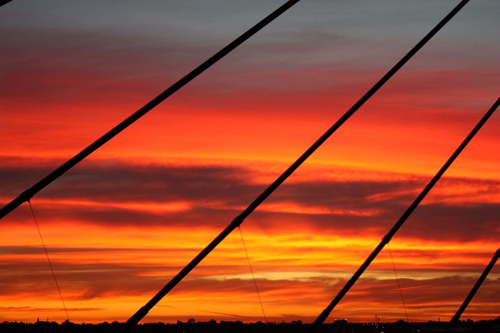
These sunset colours over the inner west suburbs of Annandale and Leichhardt are viewed between the cables of the Anzac Bridge. The bridge was known as the Glebe Island Bridge when it opened in 1995. It was renamed the Anzac Bridge on Remembrance Day, 11th November 1998, to honour the servicemen and women who served in two world wars. The name is derived from the Australian and New Zealand Army Corps (ANZAC).
Thursday, 10 November 2011
Mosman, shops
Wednesday, 9 November 2011
Mosman, war memorial

The Mosman War Memorial is located on the corner Myahgah Road and The Crescent at Mosman. The original World War 1 memorial is a large grey stone obelisk, dedicated in 1922. A flagpole, a small stone to commemorate World War 2 and a memorial sundial were added to commemorate subsequent conflicts. This memorial sits on the edge of Allan Border Oval, surrounded by six cypress trees.
Tuesday, 8 November 2011
Mosman, shops

This commercial building is located along Military Road, in the lower north shore suburb of Mosman. William Henry Smith was a speculative builder who with his partner S. H. Cabban were responsible for many buildings in the Federation architectural style in the suburb. From the late 1890s, they erected a number of shops including "The Strand" which are now part of a conservation area.
Monday, 7 November 2011
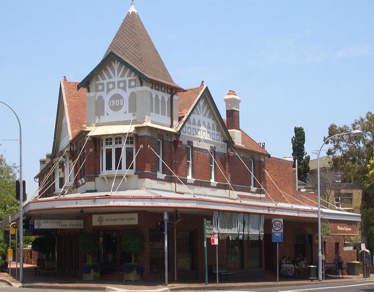
Mosman, shops

These shops are located along Military Road, in the lower north shore suburb of Mosman. It has been declared a conservation area for this early twentieth century shopping strip. The shop and residence on the corner with the turret is an example of the Federation Queen Anne architectural style.
Sunday, 6 November 2011

Saturday, 5 November 2011
Wolloomooloo, Finger Wharf

Wolloomooloo Wharf, also known as the Finger Wharf, viewed from The Domain on the foreshore of Wolloomooloo Bay. Built in 1915, it was a working wharf until the 1970s. It was redeveloped into a hotel, apartments, restaurants and a marina in the 1990s. The newer apartments built at the end of the wharf are some of the most expensive in Sydney. The name Woolloomooloo is believed to be derived from an Aboriginal word, either Wallamullah meaning 'place of plenty' or Wallabahmullah meaning a 'young black kangaroo'.
Linked to: Weekend Reflections.
Friday, 4 November 2011

Thursday, 3 November 2011
Sydenham, substation

This electricity substation No.43 is located along Unwins Bridge Road, in the inner west suburb of Sydenham. This heritage listed building was built in 1913 in the Federation Arts and Crafts architectural style, with Art Nouveau elements such as the style of lettering. Even power sub-stations were beautifully designed back then. The Municipal Council of Sydney logo (MCS), appears on the facade along with identification number "No 43" and the words "Electricity Sub-station" in relief, above the main doorway. An "Electricity Australia" sign and warning signs have been attached to the wall and roller shutter door.
Linked to: Signs, Signs
Wednesday, 2 November 2011
Wareemba, Canada Bay

This view is from the inner west suburb of Wareemba, across Canada Bay to the suburb of Canada Bay. The name Wareemba is derived from an Aboriginal word meaning "place where sweet water meets salt water".
Click here to view all participants of Outdoor Wednesday Tuesday, 1 November 2011
Customs House Square, bar (Theme Day: Fences)

This ornate ironwork fence is located along Young Street outside Quay Bar, an outdoor bar in Customs House Square near Circular Quay.
Subscribe to:
Posts (Atom)
